Cameroon's Geography. Africa in Miniature
From lush rainforests to arid deserts, Cameroon offers a unique blend of landscapes and natural beauty. Join us as we delve into the geographical marvels of this incredible country.

A Land of Contrasts
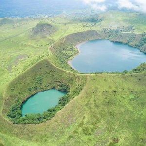
Cameroon, often referred to as ‘Africa in Miniature,’ boasts a stunning variety of geographical features. The coastal plains, dominated by mangroves and tropical rainforests, give way to the central plateau’s rolling hills and savannas. In the north, the landscape transforms into the arid Sahel region, while the western highlands are home to volcanic mountains, including Mount Cameroon, the highest peak in West Africa.
One Country, Two Climates
Natural attractions
Cameroon’s geographical features include a rich tapestry of rivers, lakes, and mountains. The Sanaga River, the longest river in Cameroon, flows through the central region, while Lake Chad, shared with neighboring countries, lies in the far north. The country is also home to numerous volcanic lakes, such as Lake Nyos and Lake Monoun, which have unique geological histories. The western highlands offer breathtaking views and hiking opportunities, particularly around Mount Cameroon.
Explore Cameroon's Beauty
Scaling the summit of Mt. Cameroon
Experience the thrill of climbing Mount Cameroon, the highest peak in West Africa, on an unforgettable adventure that offers stunning views of the surrounding landscapes. Trek through lush rainforests, volcanic terrain, and challenging slopes as you conquer this iconic mountain.
The Lobe Waterfalls
The Lobe Waterfalls, is one of UNESCO’s World Heritage sites. It offers a serene escape for adventurers seeking tranquility and awe-inspiring sights. Add this enchanting destination to your itinerary and experience the magic firsthand.


